Key Takeaways
- ExcaVision is designed to display live depth, slope, horizontal distance, and left-to-bottom or right-to-bottom measurements.
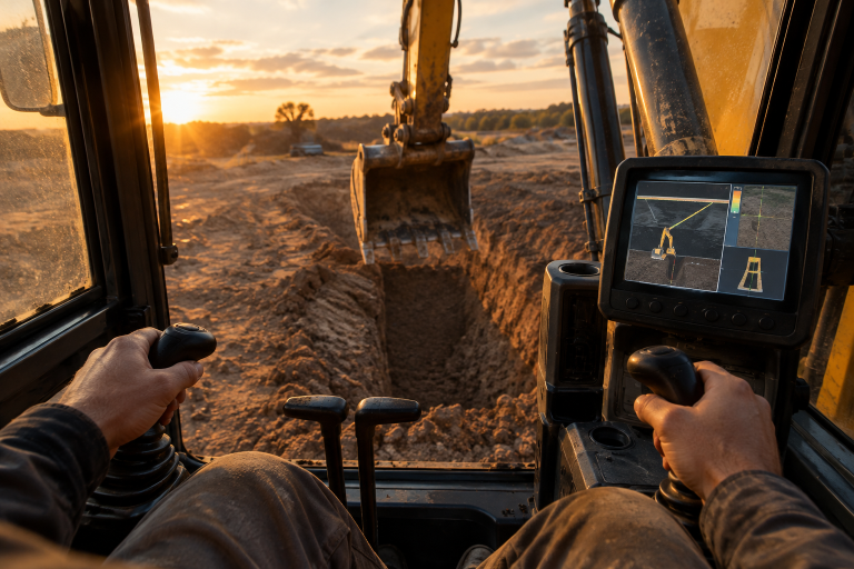
- The system uses wireless sensors on the boom, stick, and bucket, along with an in-cab display.
- ExcaVision states that a typical installation takes about one hour, depending on the machine and configuration.
- The system is intended for use on excavators and can be configured for other compatible equipment.
- Live grade information may help crews identify excavation deviations earlier, before they become larger correction tasks.
Accurate excavation depends on knowing where the bucket is relative to the required depth and slope. The excavator grade monitoring system from ExcaVision is designed to provide operators with live measurement data in the cab, helping them monitor excavation progress without relying on constant manual grade checks.
For contractors working on trenches, foundations, basements, septic systems, and similar earthwork, in-cab grade monitoring can support a more consistent workflow. It does not replace project drawings, survey control, inspections, safe excavation practices, or qualified operator judgment. It can, however, provide useful information while the machine is actively digging.
Why Does Excavator Grade Control Matter?
Excavation accuracy affects more than the hole in the ground. Final grade can influence drainage, foundation preparation, utility placement, material quantities, and the readiness of the next trade. When an area is overdug, the crew may need to replace material and compact it again. When it is underdug or cut to the wrong slope, later work can be delayed while the excavation is corrected.
Manual grade checks remain important on many projects, but they can interrupt production. An operator may need to pause, leave the cab, wait for a helper with a rod, or request verification from a supervisor or survey crew. Those steps are sometimes necessary, especially at critical control points, but repeated interruptions can make routine excavation less efficient.
How Does ExcaVision Measure Depth and Slope?
Wireless Sensors and an In-Cab Display
ExcaVision describes its system as using wireless sensors mounted on the boom, stick, and bucket. These sensor readings are displayed on a rugged cab display, providing the operator with information to use while shaping or checking an excavation. The company states that the display can show live depth, slope, horizontal distance, and left-to-bottom or right-to-bottom measurements.
The system can also be configured with an optional Laser Receiver mounted on the dipper stick. This component provides a height reference when the job calls for laser-based control. For larger sites and harbor work, ExcaVision states that its GPS-ready capability can feed bucket-location information to a suitable GPS reference.
Supporting the Operator’s Existing Workflow
Rather than requiring the operator to work from a separate office-based process, the system is intended to put relevant grade information where it is needed, inside the machine. ExcaVision also states that it stores machine and attachment information for later recall. This can be useful when a contractor uses different buckets or moves the system among compatible machines.
Which Jobsite Problems Can ExcaVision Help Address?
- Uncertain depth: Live depth information can help an operator monitor progress during excavation, rather than relying solely on periodic ground checks.
- Incorrect slope: Slope readings can help the operator recognize when the bucket position does not match the intended profile.
- Repeated cab exits: An in-cab display can reduce the need to leave the machine for routine measurement checks.
- Helper coordination: For routine grade monitoring, the operator may not need someone holding a rod at every check.
- Machine changes: Stored settings and a transferable design can simplify moving the system between compatible equipment.
- Late discovery of errors: Measurement feedback during digging can help crews detect deviations before downstream work begins.
Actual results will vary. Setup quality, calibration, machine condition, bucket dimensions, site conditions, operator experience, and project accuracy all affect excavation outcomes. Grade-monitoring equipment should be treated as a work tool, not as a substitute for required verification.
What Makes ExcaVision Practical for Contractors?
ExcaVision has provided grade-control systems since 1992 and states that a typical installation takes about one hour. Installation time matters for contractors because a system that is difficult to deploy may spend more time off the job than helping on it. The appropriate setup still depends on the specific machine, attachments, and measurement needs.
According to ExcaVision, its machine-to-machine design allows the system to move from an excavator to a compatible rental backhoe in minutes. The company also identifies excavators, backhoes, dozers, scrapers, and drills among the equipment types its grade-control approach can support, with the required configuration or software upgrade. Contractors should confirm compatibility before ordering equipment for a particular fleet.
Where Can Contractors Use ExcaVision?
Foundations, Basements, and Site Preparation
Foundation and basement work often requires repeatable depth checks before concrete, stone, or other materials are placed. Live measurement information can help an operator work toward the required excavation profile and identify potential issues earlier in the sequence.
Trenching, Utilities, and Septic Systems
Trenching and utility work can require consistent depth and slope across changing ground conditions. On residential and septic projects, a transferable system may be especially useful when the contractor works with different machines from one job to the next.
How Does Grade Monitoring Relate to Rework?
Grade control addresses one possible cause of field corrections, not every cause. Design changes, unsuitable material, weather, communication gaps, and workmanship can all contribute to rework. Still, catching an excavation-depth or slope issue before the next activity begins can be a meaningful form of risk control.
An analysis of field rework costs published by the American Society of Civil Engineers reported average precompletion rework costs of 0.38 percent of contract value, rising to 0.76 percent when estimated postcompletion corrections were included. Separately, the Construction Industry Institute defines field rework as work that must be performed more than once and links high levels of rework to cost, schedule, and productivity challenges.
How Should a Contractor Implement ExcaVision?
- Confirm the machine make, model, hydraulic configuration, and planned attachments.
- Define the required measurements, including depth, slope, horizontal distance, laser reference, and GPS integration.
- Train operators to confirm the active machine and attachment settings before beginning work.
- Establish clear points when survey, engineering, or supervisor verification is still required.
- Track grade-related corrections, waiting time, material replacement, and operator feedback after deployment.
Frequently Asked Questions
Can ExcaVision replace a survey crew?
No. It can support routine in-cab grade checks, but survey control, inspections, engineering decisions, and project-specific verification remain separate responsibilities.
Can ExcaVision monitor both depth and slope?
Yes. ExcaVision states that its in-cab display provides live depth and slope information, along with horizontal-distance and left-to-bottom or right-to-bottom measurements.
Can the system move between machines?
ExcaVision states that its system is designed for machine-to-machine use on compatible equipment. Contractors should verify the configuration needed for each machine and attachment.
Wrap-Up
ExcaVision can provide excavation crews with live information on depth, slope, and bucket position while work is underway. For contractors handling trenches, foundations, septic systems, and other earthwork, that information can support more consistent excavation and help identify potential grade issues earlier. The system should still be used alongside project plans, survey control, inspections, and qualified judgment, but it can serve as a practical tool for keeping routine excavation work on target.